


Kerala Accommodation
Kerala Amusement Parks
Kerala Archeology
Kerala Art Forms
Kerala Ayurveda
Kerala Backwaters
Kerala Banks
Kerala Beaches
Kerala Bird Sanctuaries
Kerala Builders
Kerala Cinema
Kerala Churches
Kerala Cities
Kerala Cuisine
Kerala Dams
Kerala Destinations
Kerala Dress Code
Kerala Education
Kerala Forts
Kerala Hill Stations
Kerala Hospitals
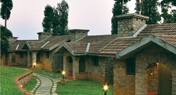
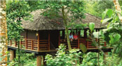
Kerala Hotels and Resorts
Kerala Map
Kerala Mosques
Kerala Museums
Kerala National Parks
Kerala News
Kerala Palaces
Kerala Pilgrimage
Kerala Reservoirs
Kerala Restaurants
Kerala Shopping
Kerala Spices
Kerala STD Code Finder
Kerala Temples
Kerala Tourism
Kerala Tour Operators
Kerala Waterfalls
Kerala Wildlife Sanctuaries
Kerala Zoos
Monsoon Tourism
Time Convertor
Kerala | KeralaTourism | Idukki Attractions
A ravine, a gorge is the meaning of Idukki in Vernacular. This beautiful, isolated district is a tiny, gorgeous gorge. Hills, dales, woods, forests, spices, cascades, lakes, rivers, rivulet, mist etc make Iduki really a dreamy land. Four main rivers of Kerala namely Periyar, Pampa, Thalayar and Thodupuzhayar enrich this district. The air of Idukki is cool and tranquil which permeates the aroma of spices. Idukki is the largest producer of spices in Kerala. Pepper, cardamom, cinnamon, clove, nutmeg etc. come from this glorious land. Apart from spices tea, coffee and rubber etc. also are harvested. Idukki has a reserved forest of about 1500 sq km that is very rich with its flora and fauna. Cheruthoni near the district headquarters is at a height of 4000 feet above sea level from where one can on look the sunrise and sunset. Idukki has a total area of 4998 sq km. While traveling upward from Thodupuzha to the sprawling height of Painavu, the district headquarter or to Cheruthoni one can establish communion with the serene nature, the scintillating beauty of forest greenery. Idukki offers diverse attractions like wildlife sanctuaries, hill stations, mountain trees, foggy spice plantation and elephant rides. Idukki has the largest concentration of tribes. The main tribes are Muthuvans, Malayarayan, Mannan, Paliyan, Urali, Malapandaram, Malavedan and Ulladan. These tribal lots of Kerala maintain a unique custom and belief and keep an ethos, which is distinctly different from the mainstream culture. The climate of the district which has 14 peaks, about 2000 meters above sea level, is subject to constant changes from West to East. Bordering Ernakulam, Kottayam districts on the West, Thrissur, Coimbatore of Tamilnadu on the North, Madurai, Ramanad, Thirunelveli of Tamilnadu districts on the East and Kottayam, Pathanamthitta districts on the South Idukki is the most gifted district of Kerala. Moolamattom hydro-electric power station situated in the district produces 60% state’s power needs.
Idukki Tourism Destinations | Idukki Hotels and Resorts

- Fact Sheet
- STD Codes
- Access
- Communication
Area: 4,358 sq km
Population (2011): 11, 07,453
Male: 5, 51,944
Female: 5, 55,509
Altitude: 935 - 2200mts above the sea level
Clothing: Tropical Cottons, Warm cloths
Tourist Season: August – March
Adimali ++ 91 4864
Idukki ++ 91 4862
Munnar ++ 91 4865
Nedungandam ++ 91 4868
Peerumedu ++ 91 4869
Thodupuzha ++ 91 4862
Air: Madurai, Tamilnadu (140km). Cochin International Airport (190 km), Ph: 0484 2610115 Rail: Theni (60 km). Changanassery (93 km). Kottayam (114 km)
Road: KSRTC Bus Station, Munnar, Ph: 04865 230201. KSRTC Bus Station, Kumily, Ph: 04869 224242.
Department of Tourism, Thekkady, Ph: 04869 222620
DTPC Information Centre, Munnar, Ph: 04865 231516
DTPC, Idukki, Ph: 04862 232248
Tourist Information, Munnar, Ph: 04865 231136, 230349
Idukki Destinations
Kumily: (4 km from Thekkady) This is a plantation town, situated on the outskirts of the Periyar Sanctuary. Kumily becomes the paradise of plantation tourism, a new trend in the tourism industry, with many plantations of various cash crops.
Idukki Wild Life Sanctuary: This sanctuary extends over the Thodupuzha and Udumpanchola taluks spreading over to 77 sq km and is about 450-748 meters above Sea level. Three dams, namely, Cheruthoni, Idukki and Kulamavu form the Idukki reservoir which extends to 33 sq km. The area is the about of various animals, snakes and birds.
Arch Dam: Asia’s first and world’s second arch dam, constructed across the Kuravan and Kurathi hills. Lies close to Cheruthoni barrage, it is 550 feet high and 650 feet wide. The beautiful Idukki wildlife sanctuary is close-by. To its west is the Kulamav Dam.
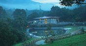
Thekkady: Thekkady brings to mind the images of elephants in their original exposure, unending chains of hills and spice-scented plantations. Thekkadi is one of the best and finest wildlife reserves in India. The altitude of this exquisite place is 900-1800 meters above the sea level.
Periyar Wild Life Sanctuary: This rich jungle of Thekkady, lying close to the plantations is one of the world’s most precious and captivating natural wildlife reserves spread across to 777 sq km of which 360 sq km is thick evergreen forest. This sanctuary was declared a Tiger Reserve in 1978. The exotic lake formed artificially by the Mullapperiyar Dam across the Periyar River adds to the charm of the Park. This is the only sanctuary in India where one can have the experience of beholding wildlife at close quarters from the safety of a boat on the lake.
Murikkady: (5 km from Thekkady) Washed in fresh spice-scented air, Murikkady is a panorama of Cardamom, Coffee and Pepper plantations.
Pandikuzhi: (5 km from Kumily) Between Chellarkovil and the border of Tamilnadu, Pandikuzhi offers great opportunities for trekking. This picturesque spectrum of exotic flora and fauna is a photographer’s delight.
Chellarkovil: (15 km from Kumily) The cascading waterfalls and the breath capturing views of the plains of this sleepy tiny village is a feast for the eyes. The village slopes down to the famous coconut groves of Cumbum in neighbouring Tamilnadu.
Mangaladevi Temple: (15 km from Thekkady) Visitors to this ancient temple are allowed only on Chithra Paurnami festival days. Hidden in the dense forest at the top of a peak 1337 meters above sea level, the temple is built in traditional Kerala style of architecture.
Vandanmedu: (25 km from Kumily) One of the largest auction centers of Cardamom in the world. A walk through the vast Cardamom plantations will be an unforgettable experience.
Vandiperiyar: (18 km from Thekkady) River Periyar separating the title town into two, makes it very fertile. There are tea factories, government agricultural farms and flower gardens in this gifted land.
Pullumedu: (43 km from Thekkady and 26 km from Periyar) The winding journey to this hill town offers a stunning view of the rolling hills draped in lush greenery. Sabarimala shrine and the Makara Jyoti illuminations at the shrine are visible from here.
Peermede: (915-1100 meters above the sea level) This famous plantation town takes its name from Peer Mohammed, a Sufi Saint and close associate of the erstwhile royal family of Travancore. Wide area of cultivation of tea, cardamom, rubber, coffee interspersed with cascades, sculptural rocks, meadows and mist-cloaked hilltops make Peermede unforgettable.
Vagamon: (25 km from Peermede) Spectacular sights make Vagamon a perfect holiday retreat. A curious blend of religious mysticism and European legacies, this hillside village is a haven of tranquility. The chain of three hills, Thangal Hill, Murugan Hill and Kurisumala is a mark of religious harmony.
Kuttikanam: Kuttikanam, a plantation town, is surrounded with picturesque green hills. Kuttikanam is a place for adventure tourism and trekking or even a languorous, tranquil break.
Pattumala: (17 km East of Peermede and 28 km West of Thekkady) The word Pattumala means hill draped in silk. The Velankanny Matha Church, built entirely of granite, at the top of the hill is a famous pilgrim center.
Ilaveezhapoonchira: (55 km from Kottayam and 20 km from Thodupuzha) Ilaveezhapoonchira means valley where leaves don’t fall. Ilaveezhapoonchira is named so because the place has no trees, spread over thousands of acres.
Thrisanku Hills: (4 km from Peermede and ½ km from Kuttikanam) The rolling hills, the lovely landscape and the gentle breeze make this an ideal spot for long walks. The hills offer a breathtaking view of the sunrise and sunset.
Peeru Hills: (4 km from Peermede and 1 km from Kuttikanam) The hill is named after Peer Mohammed, the Sufi saint, who spent his last days here. The mausoleum of the saint, the summer palace of the royal family and the residence of the Diwan situated nearby are all worth a visit.
Grampi: (5 km from Peermede and 10 km from Vandiperiyar) Grampi is also known as Parunthupara because of the panoramic view from its high peaks. The way to Grampi is beautiful with Cardamom, Tea and Coffee plantations.
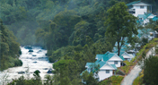
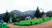
Munnar: (Altitude 5000-8000 feet above the sea level and Rainfall - 275 cm) Munnar is situated at a commingling of three mountain streams, Mudrapuzha, Nallathanni and Kundala, 1600 metres above sea level. Munnar was once the summer resort of the British in the South India. Among the exotic flora found in the forests and grasslands here is the Neelakurinji. This rarest species of flowers, which bathes the hills in blue every twelve years, will bloom next in AD 2018. Munnar also has the highest peak in South India, Anamudi which towers over 2695 meters.
Devikulam: (7 km from Munnar) This Idyllic hill station with its velvet lawns, gorgeous flora and fauna and the cool, tranquil mountain is a rare experience. The Sita Devi Lake with its mineral waters and picturesque surroundings is a good picnic spot. The Lake is ideal for trout fishing.
Pothamedu: (6 km from Munnar) Pothamedu offers an excellent view of the tea, coffee and cardamom plantations in Munnar. The rolling hills, the lush mountain and the breathtaking scenery here are ideal for trekking and long mountain walks.
Attukal: (9 km from Munnar) A panorama of waterfalls and rolling hills, Attukal located between Munnar and Pallivasal, is a feast for the eyes. The place is also ideal for long treks.
Nyayamakad: (10 km from Munnar) Located between Munnar and Rajamala, Nyayamakad is a land of breathtaking waterfalls. The waters cascade down a hill from a height of about 1600 metres.
Chithirapuram: (10 km from Munnar) With its sleepy little cottages, bungalows, old playgrounds and courts, Chithirapuram still exudes an old-world charm. Home of the Pallivasal Hydel Power Project, this hill town is also famous for its picturesque tea plantations.
Mattupetty : (13 km from Munnar) Mattupetty is known for its highly specialized dairy farm, the Indo Swiss Live Stock Project. Over 100 varieties of high yielding cattle are reared, at a height of 1700 mts. Only 3 of the 11 cattle sheds in the farm are open to the visitors.
Pallivasal: (8 km from Munnar) This is the venue of the first Hydro-electric Project in Kerala and a place of immense scenic beauty.
Kundala : (20 km from Munnar) Kundala is a picturesque town on the way to Top Station. The Kundala artificial dam is another attraction. Aruvikkad waterfall is also near Kundala. A Golf course which promotes Tata Tea Limited is situated here.
Rajamala: (15 km from Munnar) This is the natural habitat of the Nilgiri tahr. Half the world population of the rare mountain goat (Hemitragas hylocres), which is fast becoming extinct, is now found here. The Nilgiri tahrs are today reduced to small herds found in the Eravikulam-Rajamala region.
Eravikulam National Park:(15 km from Munnar) The 97 sq km park is situated in the Devikulam taluk and is home to the Nilgiri tahr. The Anamudi Peak (2695 meters) is located in the southern region of the park.
Lock Heart Gap : (13km from Munnar) This is an ideal place for adventure tourism and trekking. The fresh mountain air, the gorgeous hills and panoramic view make it worthy of a visit.
Echo Point: (15 km from Munnar) This scenic place gets its name from the natural echo phenomenon here. Echo Point is on the way to Top Station from Munnar.
Sanctuary visit: The Park is divided into three regions, the core area, the buffer area and the tourism area. Visitors are allowed only to the tourism area, which is in the Rajamala region. The Nilgiri tahr can be observed at close quarters here.
Top Station: (32 km from Munnar and 1700 meters above sea level) This is the highest point on the Munnar-Kodaikanal road. The rare Neelakurunji (Strobil-anthus) belongs to this region.
Power House Waterfalls: (18 km from Munnar) This waterfall on the way to Thekkady from Munnar cascades down a steep rock, 2000 meters above sea level. The spot is enriched with the scenic western mountain ranges, and is an ideal place for a break on the way to the Periyar Wildlife Sanctuary in Thekkady.
Anayirankal: (22 km from Munnar) Anayirankal is a lush green carpet of tea plants. A trip on the splendid reservoir is an unforgettable experience. The tea plantations and evergreen forests surround the Anayirankal Dam.
Marayoor: (40 km from Munnar) This is the only place in Kerala that has a natural growth of sandalwood trees. The sandalwood factory of the Forest Department, the caves (Muniyaras) with murals and relics from the New Stone Age civilization and the children’s park spread across a hectare of land under the canopy of a single Banyan tree are of great interest to tourists.
Cheeyappara: The Cheeyappara waterfall is located between Neriamangalam and Adimali on the Kochi - Madurai highway. The Cheeyappara Waterfalls cascade down in seven steps.
Valara: It is located on the Kochi-Madurai Highway. The surrounding thick forest adds beauty to this cascade.
Meenuli: It is noted for two acres of evergreen forests upon a huge rock. The rock is more than 500 acres in area and an ideal spot for mountaineering.
Malankara Reservoir: (6 km from Thodupuzha) Located on the Thodupuzha-Moolamattam road, this artificial lake is ideal for boating and fishing.
Thommankuthu: (17 km from Thodupuzha) The seven-step waterfall here is a much loved picnic spot. At each step there is a cascade and a pool beneath. Thommankuthu is an ideal place for adventure tourism.
Ramakalmedu: (16 km from Nedumkandam) Rolling green hills and the fresh mountain air make Ramakalmedu an enchanting retreat. The hilltop also offers a panoramic view of the picturesque villages of Bodi and Cumbum on the eastern slope of the Western Ghats.
Keezharkuth: (25 km from Thodupuzha) The Rainbow waterfalls, which cascade down a rock from a height of about 1500 meters is a wonderful attraction of this spot.
Chinnar Wild Life Sanctuary: (7 km from Munnar) This Idyllic hill station with its velvet lawns, gorgeous flora and fauna and the cool, tranquil mountain is a rare experience. The Sita Devi Lake with its mineral waters and picturesque surroundings is a good picnic spot. The Lake is ideal for trout fishing.
Palkulamedu: (12 km from Idukki and 3125 meters above sea level) Kochi, Alappuzha and other nearby towns can be seen from this peak.
Kalliyanathandu:(10 km from Idukki) The aerial view of the Idukki Reservoir, panoramic view of peaks and forests makes this is a splendid tourist spot.
Thumpachi Calveri Samuchayam: (35 km from Thodupuzha) This is a picnic spot also ideal for meditation, relaxation and watching sunset.
Nadukani: (25 km from Idukki) True to its name Nadukani offers a panoramic view to a large area than one can experience from any high mountain park. A two storeyed pavilion makes an ideal place for enjoying the landscape and beauty of nature.
Thodupuzha Sree Krishna Temple:This temple is located in the Holy land which was very big beautiful garden in the ancient times. Thodupuzha River which flows through the Southern side as a procession makes the temple and its surroundings more aesthetic and beautiful.
Kalvari Mount: This is a famous pilgrim center on the way to Kattappana.
Blossom International Park: Sprawled over 16 acres, this park has a garden with a profusion of blooms and a plethora of activities for adults and children including boating, cycling, games etc.


Kerala Tourism | Kerala Pigrimage | Kerala Real Estate | Kerala Health Care | Info Kerala | Contact Us | Home

![]()